


Getting Here
Planning a visit to Downtown Langley? You’ll find it easy to get here—and even easier to stick around. With free parking, a walkable core, and over 500 shops, restaurants, and services, everything you need is just steps away.
View Map
Click below to view or download a map of Downtown Langley:
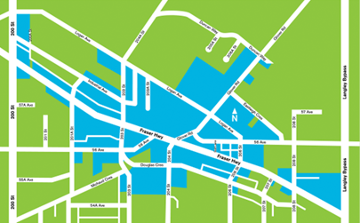
Click the map for a larger view, or download a printable PDF (see below).
How To Get Here
Driving Directions
From Vancouver
- Take Highway 1 East (Trans-Canada Hwy)
- Take Exit 58 (200 Street)
- Head south on 200 Street
- Turn left onto Fraser Highway
From Abbotsford
- Take Highway 1 West
- Take Exit 66 (232 Street / Highway 10)
- Follow Highway 10 west
- Turn left onto Glover Road
- Turn left onto Fraser Highway
From the USA (Peace Arch / Pacific Highway)
- Cross the border via Highway 15 North
- Turn right onto 56 Avenue (Highway 10)
- Turn right onto Fraser Highway
Public Transit
Downtown Langley is accessible by bus from across the Lower Mainland.
Plan your trip with TransLink, click here.
Once you’re here…
Explore local shops, grab a bite, or check out what’s happening downtown.